By Kaaren Joubert, Planning Manager, Cato Bolam Consultants.
Two recent updates from Watercare and central government are set to influence how and where growth can occur across Auckland. These changes affect both infrastructure planning and urban development zoning.
Watercare Updates Capacity Maps
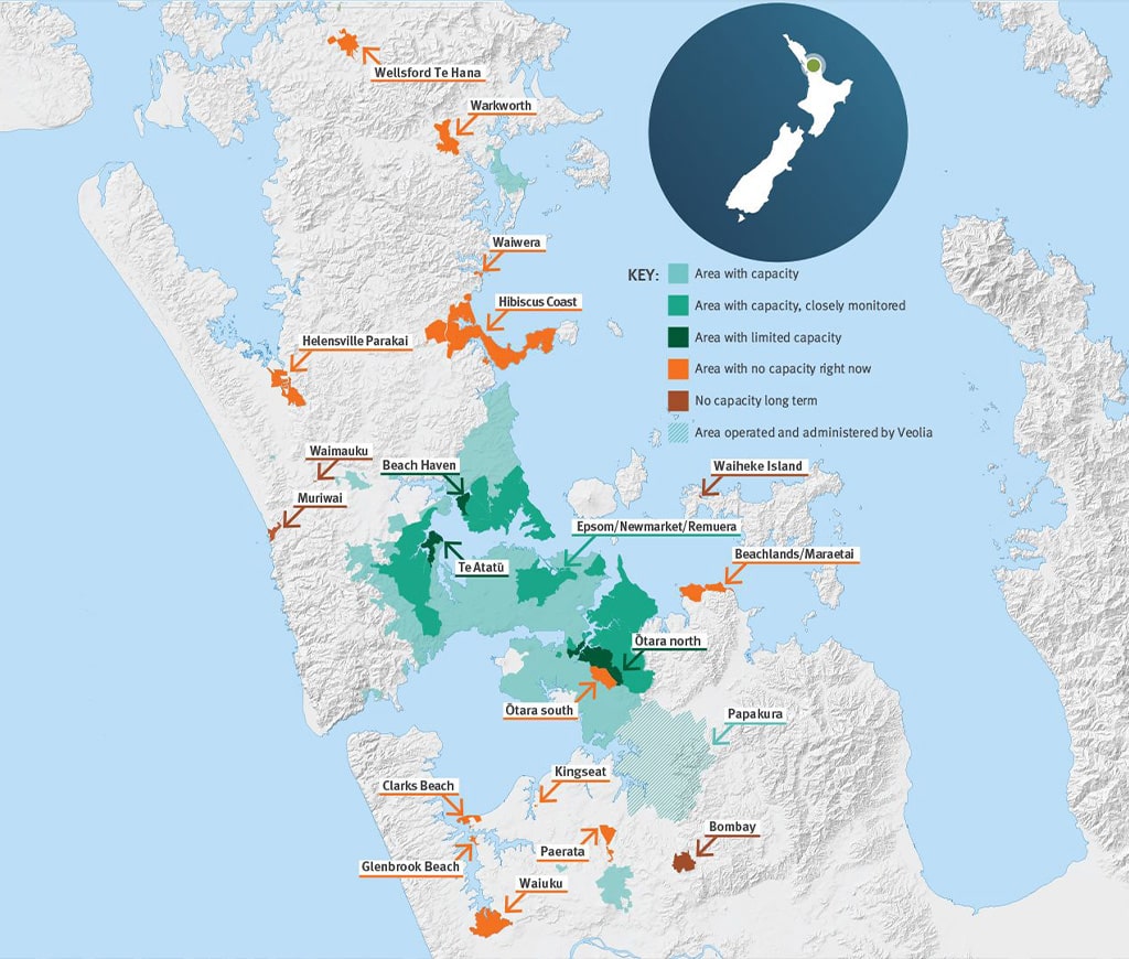
Watercare has released an updated version of its network capacity maps, aimed at improving clarity around where infrastructure can support growth and where closer monitoring is in place. The update responds to a common misperception that areas shown as having limitations are effectively closed to development — in reality, Watercare has confirmed capacity in more than 3000 of the 3400 development-related queries received since the maps were first published in November 2024.
The revised maps now present overall area status rather than listing water or wastewater limitations separately, and are based on refreshed network performance data, including overflow frequency and environmental risk. Some locations — including Glendowie, Otāhuhu, East Tāmaki / Flat Bush, and Epsom / Newmarket / Remuera — are now being monitored more closely due to potential future constraints on the network, despite generally having sufficient capacity in bulk infrastructure.

📍 More information and the updated map are available here:
Watercare – Updated Network Maps
📄 Download the full capacity map (PDF):
Network Capacity Table – June 2025
🗓️ Upcoming Watercare Seminar
To support these updates, Watercare is hosting a free online seminar for developers, planners and infrastructure consultants. The session will cover how to interpret the revised maps and what the changes mean for development feasibility and consenting processes.
- Date: 26 June 2025
- Time: 9:00am – 10:00am
- Join link: Microsoft Teams Event
This is a useful opportunity to hear directly from Watercare’s team and ask questions about specific zones or projects.

PC78 Withdrawn: New Direction for Housing Intensification
The Government has announced changes to Auckland’s housing intensification strategy, including the withdrawal of remaining parts of Plan Change 78 (PC78) and replacing it with a new plan change by 10 October 2025.
Highlights:
- Auckland Council has finalised the city centre component of PC78, increasing development capacity in the CBD.
- The remainder of PC78 can now be withdrawn, with Council required to notify a new plan change by 10 October 2025.
- The replacement must enable housing capacity equal to or greater than what was proposed under PC78.
- Additional requirements will apply for greater density around key City Rail Link (CRL) stations, including: Maungawhau (Mount Eden), Kingsland and Morningside
This shift aligns zoning rules with significant public investment in rapid transit infrastructure. Read the full announcement: Saying Yes to More Housing – Beehive.govt.nz

Have Questions? Talk to Our Planning Experts
Our planning team can help you to:
- Benefit from the Medium Density Residential Standards while it is still in place
- Review zoning or capacity constraints and advocate on your behalf
- Assess risks at resource consent stage
- Identify areas with emerging development potential
📞 Contact us to discuss how these changes may affect your project — our planning team can provide practical, expert advice.

