WHAT WE DO
Flood Assessments & Modelling
At Cato Bolam, we specialise in integrating flood management solutions into land development projects, whether it’s a single house or a large-scale master-planned development. With decades of experience, we leverage the latest technology to provide accurate and detailed flood risk assessments.
Why Flood Assessments Matter
Flood assessments are critical in today’s regulatory environment to ensure both compliance and safety. Early flood management solutions can prevent costly delays during the resource consent process. Our expert team uses 2D modelling to assess pre- and post-development flood scenarios, helping you design resilient outcomes that account for future climate change impacts.
Collaborating for Success
Our engineers work alongside architects, civil engineers, and other specialists to develop proactive, robust flood management strategies. Collaboration ensures a comprehensive design that mitigates risks while aligning with council requirements.
Withstanding Extreme Weather Events
Following recent extreme weather events, including the 2023 Auckland Anniversary floods and Cyclone Gabrielle, local authorities are increasingly scrutinising land development in or near flood-affected areas to determine if current regulatory standards are adequately resilient. Notably, most recent urban developments designed to existing Council standards have successfully withstood these extreme flood events as anticipated.
Proven Success: Kumeu Town Centre
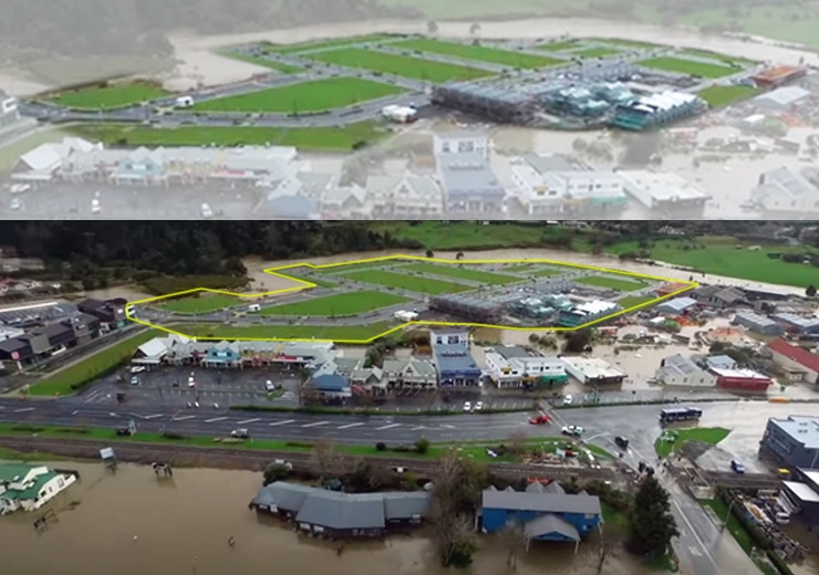
The Kumeu Town Centre is a prime example of a development that performed as designed during the extreme weather events of 2021 and 2023.
Cato Bolam led the flood mitigation design for this flood-prone site near the Kumeu River, coordinating inputs from architects, urban designers, traffic consultants, civil engineers, and the modellers. The design and flood modelling were rigorously reviewed by the Council and accounted for both existing conditions and future development plans.
The photo to the right shows the Kumeu Town Centre during the 2021 flood, where the floodwaters followed the predictions of the design model. An independent review commissioned by Auckland Council in 2022 confirmed the model’s high accuracy.

Flood Mitigation and Remediation
Effective flood mitigation involves designing solutions that reduce or prevent flood risks to property and infrastructure. At Cato Bolam, we assess the site-specific flood hazards and implement mitigation strategies such as stormwater management systems, raised building platforms, and landscape modifications to direct water flow away from key areas. Additionally, our flood remediation services help restore and stabilise land that has been damaged by flood events, ensuring long-term resilience and compliance with local regulations.
We deliver resilient, functional flood management solutions for clients, communities, and future generations.
Contact us today to discuss your project’s flood assessment and modelling requirements.


